
The 30° seasonal prompt is based on the Sun’s highest point that day
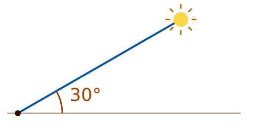
Solar elevation is the angle between the Sun’s direction and the local horizontal. The Sun rises and sets each day; here, the comparison is with the highest angle it reaches that day, usually near local solar noon, rather than its angle at the moment you look.
A seasonal prompt to pay attention to dietary sources of vitamin D appears when the Sun’s highest position that day is below 30°; it does not appear when the highest position is exactly 30°. The 30° mark helps explain how solar elevation changes with the seasons. The prompt can help you pay attention to dietary sources of vitamin D at that time of year. Personal nutritional status should be considered with other information.
Latitude boundaries and angle ranges are geometric approximations; city examples use representative coordinates.
Three regions based on the annual pattern
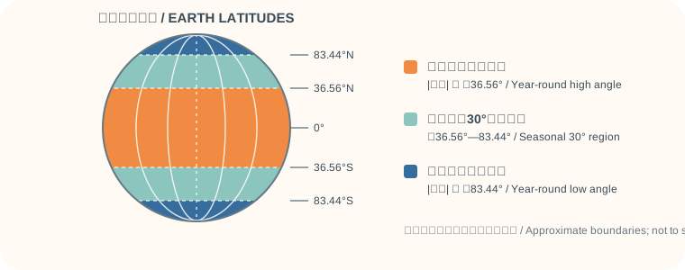
Places can be grouped by how the daily maximum solar elevation relates to 30° through the year: always above 30°, crossing or touching 30° during the year, or always below 30°. The middle group also includes boundary locations where an annual extreme is exactly 30°.
Scroll the table horizontally; latitude boundaries are approximate.
| Region | Definition by solar elevation | Approximate latitude range | What this means in everyday life |
|---|---|---|---|
| Year-round high-angle sunlight region | The daily maximum solar elevation is strictly above 30° every day of the year | Absolute latitude is below about 36.56° north or south | The Sun’s highest position is above 30° every day of the year, so this 30° seasonal prompt does not appear. |
| Seasonal-crossing 30° sunlight region | The annual minimum daily maximum is ≤30°, and the annual maximum is ≥30°; boundary locations may only touch 30° | Absolute latitude is about 36.56° to 83.44° north or south, including both boundaries | Except at locations on the lower-latitude boundary of about 36.56°, the Sun’s highest position falls below 30° on some days of the year, and a seasonal prompt to pay attention to dietary sources of vitamin D appears on those days. At the lower-latitude boundary, the Sun’s highest position reaches 30° but does not fall below 30°. |
| Year-round low-angle sunlight region | The daily maximum solar elevation is strictly below 30° every day of the year | Absolute latitude is above about 83.44° north or south | The Sun’s highest position is below 30° every day of the year, so every day meets the condition for this seasonal prompt. |
These latitude ranges are approximate boundaries to help explain the three regions. City examples use representative coordinates. In a large city, latitude can vary between districts, so a classification based on one representative point may not apply to every location in the city.
Latitude boundaries and angle ranges are geometric approximations; city examples use representative coordinates.
Why the boundaries are around these latitudes
These boundaries come from the range of the Sun’s position as the seasons change. The simplified geometric relationship below shows how the latitude values are estimated.
Earth’s rotation axis is tilted by about 23.44° relative to its orbital plane. Let φ be the location’s latitude, δ be the Sun’s declination, and ε≈23.44° be Earth’s axial tilt. The geometric solar centre’s elevation at local solar noon is approximately:
Daily maximum solar elevation h(d) ≈ 90° − |φ − δ(d)|
During the year, solar declination ranges approximately from −ε to +ε; therefore, the approximate annual minimum daily maximum solar elevation is90°−(|φ|+ε), and the approximate annual maximum is 90°−max(0, |φ|−ε). Comparing these two values with 30° gives the three latitude ranges:
- Year-round high angle: `|φ| < 60°−ε ≈ 36.56°`;
- Seasonal crossing of 30°: `60°−ε ≤ |φ| ≤ 60°+ε`, about `36.56° to 83.44°`;
- Year-round low angle: `|φ| > 60°+ε ≈ 83.44°`.
About 36.56° and 83.44° mark the boundaries of the middle region. At about 36.56°, the annual minimum daily maximum is about 30°; at about 83.44°, the annual maximum is about 30°. A boundary location may therefore reach exactly 30° without having any days below 30°. The seasonal prompt appears only when the local daily maximum is strictly below 30°; it does not appear at exactly 30°. These latitude values are simplified spherical-geometry estimates and do not account for terrain, atmospheric refraction, or the Sun’s apparent radius.
Latitude boundaries and angle ranges are geometric approximations; city examples use representative coordinates.
City examples for each region
The table lists approximate latitudes for representative points in each city to help you compare the three regions. Coordinates vary between districts in large cities; near the 36.56° or 83.44° boundaries, classification may differ by location.
Open a place-name record for coordinates; on a phone, swipe horizontally to read the table.
| Region classification | Example cities in China | Example cities elsewhere |
|---|---|---|
| Year-round high-angle sunlight region (|latitude| < about 36.56°) |
| |
| Seasonal-crossing 30° sunlight region (about 36.56° to 83.44°) |
| |
| Year-round low-angle sunlight region (|latitude| > about 83.44°) | No Chinese city is listed here; city latitudes in China do not reach this approximate range. | No city is listed here for this latitude band. As a location example, use Amundsen–Scott South Pole Station (90°S); it is a research station, not a city. |
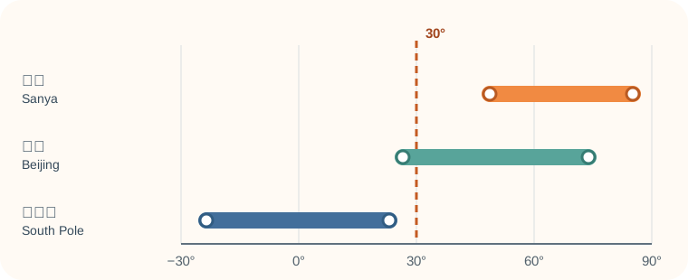
For example, in Sanya at about 18.25°N, the Sun’s highest position is above 30° every day of the year. In Beijing at about 39.91°N, it falls below 30° in winter and rises above 30° in summer. At the South Pole, the annual maximum is about 23.44°. These examples show how the Sun’s position changes with latitude and season; they do not indicate the number of sunny days or local UV intensity.
How to read a region and a daily prompt
The three regions describe the approximate range of the Sun’s highest position at a location over the year. Whether a seasonal prompt appears on a given day depends on whether the Sun’s highest position there is below 30° that day. Two places in the same region may therefore have different prompts on a particular date. Near 30°, do not rely only on a rounded display value.
These three categories describe only the Sun’s position in the sky. They do not indicate clear or cloudy weather, and they cannot replace information about sunshine duration, UVI, vitamin D production, or an individual’s nutritional status. When going outdoors, use the day’s UV index and weather to guide protection. Dietary sources of vitamin D can be considered throughout the year.
Learn about the 30° seasonal prompt rule · See vitamin D food sources and label guidance · Read the UV protection guide